366 Views
Added
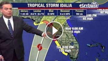
FOX 13 Meteorologist Jim Weber continues to watch Tropical Storm Idalia as it begins to strengthen. He says it is currently a tropical storm, but it is expected to become a hurricane Monday night or Tuesday morning and intensify as it moves along warm waters in the Gulf of Mexico. A hurricane warning is in place from Longboat Key through the Big Bend Area. As of 11 a.m., Idalia has wind of 65 miles an hour. He cautions Floridians to pay attention to the forecast cone and not the center line of the storm because any jog in the forecast will change the impact to the Bay Area. Southern counties on the west coast of Florida will begin to see tropical storm-force winds beginning Tuesday evening, while the rest of the area experience the winds Tuesday night and into Wednesday morning. A storm surge of 4-7 feet is also likely in Tampa Bay.Get your tropical weather forecast each day during hurricane season from the meteorologists at FOX 13 Tampa Bay and MyFoxHurricane.com. We'll issue a new hurricane update each day, and more frequently when needed.
Subscribe to FOX 13 News: https://www.youtube.com/FOX13TampaBay?sub_confirmation=1
More tropical weather videos: https://www.youtube.com/playlist?list=PLrUTXYgsKmP7jZBJPGWzCmX1Gi9QXg3nb
Tropical maps and models: https://www.myfoxhurricane.com/
Watch more FOX 13 News video: https://fox13news.com/
Watch FOX 13 News live: https://fox13news.com/live
Download our free SkyTower Radar app: https://www.fox13news.com/apps
More FOX 13 weather coverage: https://www.fox13news.com/weather
Get our newsletter: https://www.fox13news.com/email
- Category
- News
- Tags
- hurricane idalia, florida hurricane, idalia track


Comments